Heceta Water District was organized in 1966 to provide potable water to residents immediately north of Florence, Oregon. After considering several water supplies, Clear Lake was chosen as the most desirable water source in 1967. The first permit to withdraw water from Clear Lake was obtained in 1968, and the District started delivering water in 1969.
The District draws all of its domestic drinking water from Clear Lake. The district boundaries encompass about 11 square miles. We serve approximately 2,200 homes (estimated 4,500 people) within the district.
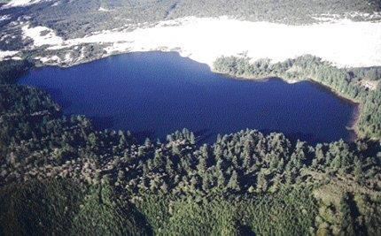
Clear Lake is one of many lakes on the central Oregon coast that lie on the 50-mile long North Florence Dunal Aquifer, an important groundwater body supplying for domestic needs in the Florence area. The Clear Lake Watershed is situated north of Florence, within the North Florence Dunal Aquifer, which was designated a ‘sole source aquifer’ by the Environmental Protection Agency on October 7, 1981. A sole source aquifer is an aquifer which has been determined to be the sole or principal drinking water source for the area.
Clear Lake is an oligotrophic lake, which means it is a lake with a limited supply of nutrients, therefore it is biologically unproductive with very transparent waters which are fully saturated with dissolved oxygen.
A 1985 study for Lane County showed that micro-organism growth increased when phosphorus was added to the water in Clear Lake – especially when the water was enhanced with nitrogen. Micro-organisms showed little increase in growth with the addition of nitrogen only. Therefore, it appears phosphorus is the major limiting nutrient. Increased phosphorus concentrations could lead to the abundance of various species of algae, including obnoxious species such as blue-green algae which can grow to excess. Increased algae abundance in the lake will lead to higher turbidity values in the summer. Because of stratification in concentration of phosphorus, it is difficult to detect change in phosphorus concentration before it becomes severe enough to cause noticeable changes in the lake.
The flushing rate in the lake is about once every 500 days. In the winter, when the lake is flushed most rapidly, it is well oxygenated. Under these conditions, phosphorus is likely to be bound to the sediment at the bottom of the lake and not susceptible to being washed out of the lake.
The following information about Clear Lake is from the Atlas of Oregon Lakes, printed in 1985 by Portland State University.
Clear Lake is one of a string of lakes on the central Oregon coast that lies on the 50 mile long North Florence Dunal Aquifer, an important ground water body supplying water for domestic needs in the Florence area. Heceta Water (People’s Utility) District withdraws directly from Clear Lake.
The geologic origin of all the lakes in this group (Collard Lake, Clear Lake, Ackerley Lake and Munsel Lake) can be explained simultaneously. The Dunal Aquifer is an accumulation of aeolian (wind blown) sand that rests on an ancient wave cut terrace. This terrace can be seen at 50 to 150 feet above sea level along the coast to the north near Newport, and to the south near Bandon and Port Orford.
However, along the coastal stretch from Coos Bay to Heceta Head, the terrace has been warped downward below sea level and an extensive accumulation of sand has been deposited on it. This dune sheet is of fairly recent geological origin. Carbon-14 dating of woody material deposited at the base of the sand and on top of the terrace clays show that it originated about 27,000 years before the present. The dune sheet is broad and relatively flat and is composed of successive layers of sand that were built up as deflation plains behind eastward migrating sand dunes. The remnants of those dunes that have become stabilized and those which have not are the major topographic features on the dune sheet surface.
Clear Lake and others in this string lie along the eastern margin of the dune sheets, between the buildup of the dune sheet to the west and next to impermeable bedrock to the east. As the migrating dunes approach the hills, the wind loses its ability to transport sand and the largest portion of the sand remains to the west, thus leaving a depression or series of troughs along the base of the hills. Collard, Clear and Munsel Lakes are thus due to marginal ponding by dune masses, a mode of formation typical of many other lakes on the Oregon coast.
The sands of the North Florence Dunal Aquifer are a substantial water holding and transporting system. Permeability is high as indicated by a lack of streams originating on the sands, in spite of over 60 inches of annual precipitation. Most of the water percolates into the sand and discharges directly to the ocean. The only surface streams that cross the dune sheet, Sutton Creek to the north and the Siuslaw River to the south, derive most of their flow from the hills to the east; there is also substantial discharge of groundwater into these streams from the aquifer. The primary internal surface drainage system begins near Collard Lake and flows through a small stream to Clear Lake.
A steady, year round flow of 1 to 2 cfs occurs in this stream. A portion of the outflow from Collard Lake flows to Clear Lake through sand that forms their western boundaries. Clear Lake water flows out by a surface stream to Ackerley Lake and then to Munsel Lake and Munsel stream or it seeps into the sand aquifer system directly from the lake. Bottom material in Clear Lake is mostly clean sand. Small deposits of clay and organic mud occur along the north shore, in coves along the east shore, and at the outlet. These small clay and mud deposits are also the spots where a few macrophytes grow: water lilies, water shield, and rushes.
The most obvious features of the surrounding landscape are the areas of bare, mobile sand which contrasts strikingly with the general forest cover. On the west side of the lake is the exposed ridge of a large active sand dune that is moving slowly eastward, encroaching on the water. Sand is constantly deposited in the lake on this side so that the bottom slopes away gently from the shore. In contrast, there is a steep slope on the east side of the lake basin where it abuts the abrupt rise of the Coast range. The original forest on the eastern side of the drainage basin has been mostly logged off and is now covered partly by a second growth conifer forest, mixed with deciduous species and partly by brush such as salal, rhododendrons, and huckleberry. Most of the land on these forest and brush covered slopes is owned by private timber companies.
Development around Clear Lake is minimal. The lake is reported to contain cutthroat trout and largemouth bass, but is not fished heavily, nor used for any other recreation purposes.
Most coastal lakes in Oregon are either mesotrophic or eutrophic, due to a combination of heavy use, shallow depth, and rapid infilling of sediment. Clear Lake, however, is quite deep and is one of the few oligotrophic lakes on the coast. Woahink Lake and the Clear Lake south of Reedsport are two other examples of deep oligotrophic coastal lakes. The water quality in Clear Lake is generally excellent. Chemical constituents exist in low concentrations due to the relatively inert quality of fresh sands and the high flushing rate from heavy rainfall and rapid groundwater movement. There is only slight enrichment of sodium and calcium and the alkalinity is very low. The concentrations of phosphorus and chlorophyll and the transparency indicate a lower trophic state than Collard Lake which discharges into Clear Lake from the north. All indications show that Clear Lake is relatively unproductive. Phytoplankton densities are low and only about 10% of the lake is shallow enough to permit the growth of macrophytes; they are not a problem as in so many of the coastal lakes.